

As rain pours over West Bay, residents in East End enjoy the sunshine. Meanwhile, rough waves roll over South Sound, as tourists on Seven Mile Beach relax in calm, placid waters.
Residents of the Cayman Islands know weather and sea conditions from one side of the island to the other can vary drastically. A drive around a curve of Grand Cayman can quickly reveal an entirely different day.
Meteorologists at the Cayman Islands National Weather Service hope that investments in forecasting equipment and research capabilities will facilitate better predictions and understanding of the islands’ often variable conditions.
A multi-million-dollar weather facility is expected to usher in a new era of weather forecasting in the Cayman Islands when it opens in late 2021. Upgrades are expected to allow greater understanding not just of weather patterns, but of climate change, beach erosion and flood zones.
National Weather Service Director General John Tibbetts says the new facility will help his staff of meteorologists and forecasters to fulfil their potential, by providing more accurate forecasts, as well as expanding the products and services they currently offer.

In 2010, the then Cayman Islands Airports Authority’s Meteorology Office became the National Weather Service. Under the former role as a met office, the forecasters primarily provided predictions to the CIAA, which would in turn pass those on to pilots arriving and departing from the Owen Roberts International Airport.
About 60% of the services cater to the CIAA. However, the new facility will see a stronger focus at targeting other sections of the community.
“There are a number of other things outside of aviation that the weather service can play a significant role in,” Tibbetts said. “We are talking about support for agriculture, support for maritime, support for tourism, [and] sports-related events, for example.”
A key feature of the facility will be the inclusion of automated weather stations that will be dispersed throughout the districts on each island. “The building isn’t everything,” Tibbetts said.
“There are also a lot of tools that we need to have. Think about it for a second. When the Cayman Islands National Weather Service says, ‘you have three inches of rain [that] fell last night,’ that is a measure of what fell at the airport. Meanwhile, a farmer out in East End is trying to figure out where all that rain is because he knows it didn’t fall in East End.”
Tibbetts says the data that they have, “doesn’t tell the whole story” and is specialised for the airport. However, the new automated stations will be able to gather real-time data and transmit it back to the weather service, which can then pass it on to the general public. Each automatic station will be designed with a specific target audience or stakeholder in mind.
“In East End, the more important stakeholders are farmers,” Tibbetts said. “So, some of the data and some of the products that will come out from that automatic station will be agricultural in nature. On the other hand, if you are looking at an automatic weather station on the Seven Mile Beach somewhere, maybe when you go to the beach you want to know if you are going to get a nasty sunburn or not, so, it will have products more generated along the lines of tourism.”
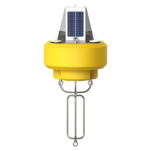
Along with the new automated weather stations, the National Weather Service is teaming up with the Department of Environment to purchase six new weather buoys that will be placed throughout Cayman’s waters. Currently, there are seven buoys that are actively gathering wave data, three of which are not working. None of those buoys belongs to the weather service.
“From the National Weather Service’s point of view, we are obviously looking at winds and waves and we are looking at sea currents,” Tibbetts said. “We have had a number of drownings over the years in various parts of the Cayman Islands. There are always times when we have a lot of danger… and so we need to have a proper network of buoys to provide those warnings.”
Tibbetts says a buoy will be tethered in the Stingray City area to provide vital information about wind and sea conditions.
Climate change and storm research
Facilitating daily gathering of information for weather predictions is only half of the purpose of the new facility.
“A part of the idea about providing future products is research, and the building is designed, and the whole organisational structure is designed, for us to be able to carry out research that will assist the National Weather Service to be able to provide more products to the Cayman Islands,” Tibbetts said.
For years the NWS has collected data on Cayman’s climate. Lack of resources at the current CIAA location, however, has meant not much progress has been made with extrapolating the data, or with identifying the potential impacts climate change has had on Cayman.
In 2011, the Caribbean Community Climate Change Centre collected data from the NWS. When interpreted, the data showed a great level of consistency and accuracy in NWS forecasts and predictions. The analysis also exposed potential risks such as beach erosion, reef and fisheries decline, as well as higher insurance premiums.
Tibbetts says their new $3 million, three-storey facility will allow his staff to monitor the effects of climate change on Cayman and pass on their findings to help with regional research efforts.
“Our climate department is working with our regional training and climate centre in Barbados, the Caribbean Institute of Meteorology and Hydrology,” he said.
The new facility will also allow the NWS to conduct crucial storm-surge research, which will identify Cayman’s most vulnerable points during the event of a natural disaster, such as a hurricane or a tsunami. The facility will also strengthen an ongoing partnership between the NWS and Hazard Management Cayman Islands to predict flooding patterns.
“Hazard Management has been doing some flood mapping and stuff like that,” Tibbetts said. “The National Weather Service will bring in a high-detail, high-level rainfall model to work hand-in-hand with this detailed data, and we will be able to predict where flooding will occur in the Cayman Islands.”
The new facility will also allow the NWS to operate 24 hours a day, which in turn will allow them to monitor earthquake activity and potential tsunamis.
“The traditional way that most Caribbean islands deal with earthquakes and tsunamis is to run it through the national weather services,” Tibbetts said. “Right now, if there is a tsunami threat to the Cayman Islands, the National Weather Service provides guidance with regards to wave heights or onsets of these tsunamis.”
In order to deliver on the new products and services, the NWS will also increase its staff. However, it won’t be until 2021 before the changes come into effect.
Related Videos


Would AWSs expose general public to RF electromagnetic fields? If so, would it be within guideline levels?